
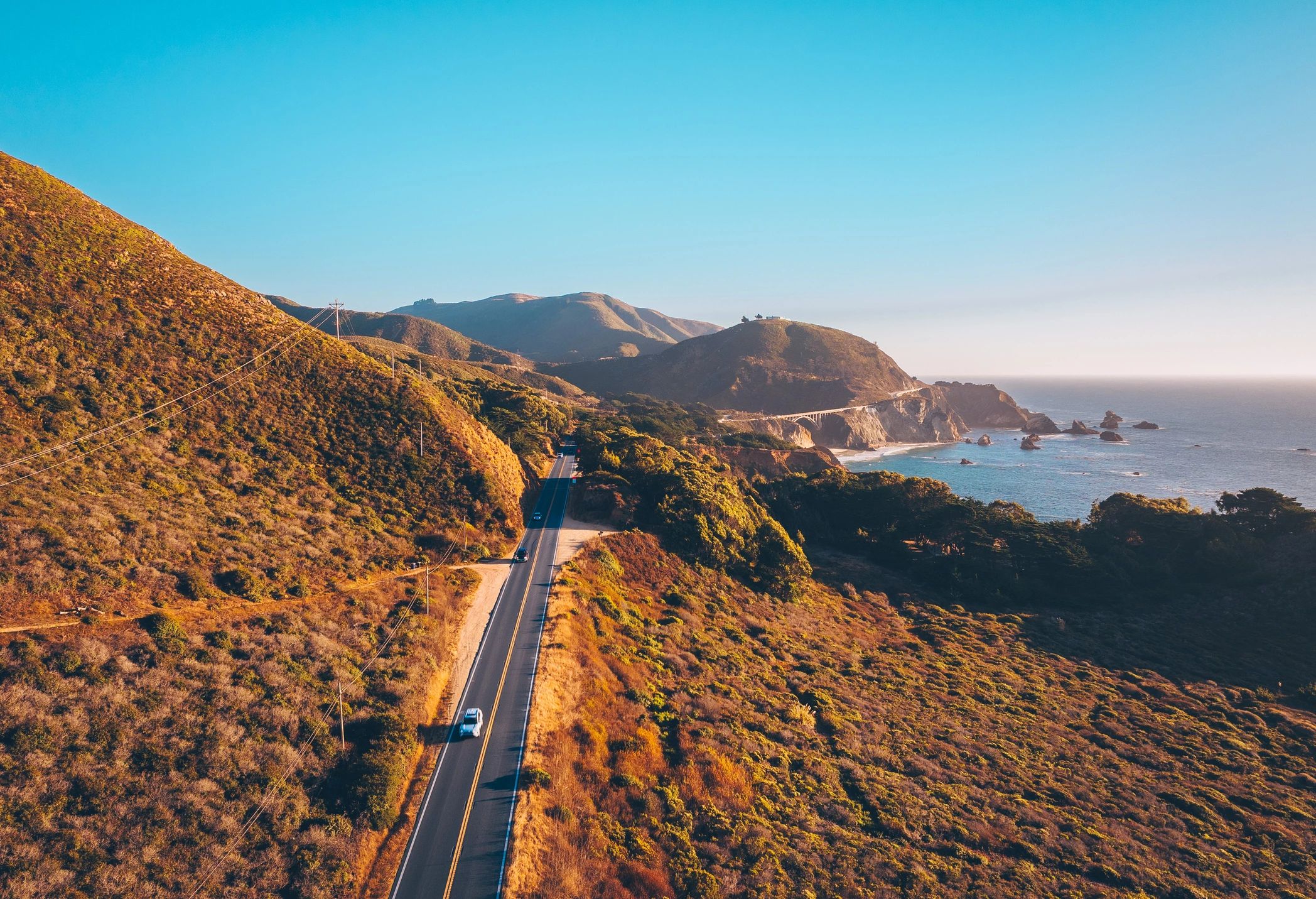
Where the Ocean Meets the Open Road: A Journey Along California’s Most Iconic Highway
Stretching over 650 miles along the rugged edge of the American West Coast, the Pacific Coast Highway isn’t just a route—it’s a destination in itself. Carved into cliffs and flanked by the endless blue of the Pacific, this legendary drive links dramatic seascapes, redwood forests, and sun-kissed coastal towns from Dana Point to Mendocino. Known officially as California State Route 1, it’s long been celebrated as one of the most visually stunning road trips in the nation, blending natural wonder with cultural richness.
Travelers who take on the PCH aren’t just passing through scenic overlooks—they’re navigating elevation changes, seasonal weather shifts, and varying road conditions that demand preparation. Coastal fog, especially in Big Sur and San Francisco, can reduce visibility, while narrow, winding segments require careful handling, particularly for larger vehicles. Planning your route with consideration for daylight hours, rest stops, and fuel availability enhances both safety and enjoyment.
Along the way, you’ll encounter historic Route 1 landmarks, surf towns like Santa Cruz and Morro Bay, and access points to state parks such as Julia Pfeiffer Burns and Point Lobos. These stops provide more than photo opportunities—they’re gateways to understanding coastal erosion patterns, marine conservation efforts, and the region’s indigenous heritage.
In the following sections, you’ll learn best practices for trip planning, ideal times to drive based on regional microclimates, packing essentials for changing coastal conditions, and strategies for supporting sustainable tourism along this fragile and beloved corridor.
Plan Your Pacific Coast Highway Adventure: A Step-by-Step Guide
Embarking on a Pacific Coast Highway journey requires thoughtful preparation to maximize safety, scenery, and satisfaction. Follow this step-by-step guide to ensure a seamless coastal experience.
1. Choose the Best Time to Travel
Aim for late spring (May–June) or early fall (September–October) when weather is stable, crowds are thinner, and visibility is optimal. Summer brings tourists and fog to northern stretches; winter raises landslide risks, especially around Big Sur.
2. Map Key Stops and Overnight Points
Break the drive into manageable segments with purposeful stops. Prioritize iconic spots like Bixby Creek Bridge, McWay Falls at Julia Pfeiffer Burns State Park, and Hearst Castle. Include lesser-known gems such as Limekiln State Park and the coastal trails near Cambria for a balanced mix of adventure and solitude.
3. Prepare Your Vehicle Thoroughly
Schedule a pre-trip inspection: check brakes, tires (including spare), fluid levels, and wipers. If driving a motorcycle or convertible, pack weather-resistant gear. Ensure your rental or personal vehicle has reliable navigation and a phone mount.
4. Pack Smart and Stay Safe
Bring layers—coastal temperatures fluctuate sharply. Include a first-aid kit, flashlight, and emergency supplies. Avoid distractions during cliffside stretches—pull over at scenic turnouts to enjoy views and recharge.
5. Respect Road Conditions and Local Closures
Monitor Caltrans for real-time updates on construction or closures, particularly on Highway 1 between Carmel and San Simeon. Fuel up whenever possible—services are sparse in remote zones.
5 Iconic Stops That Define the Pacific Coast Highway Experience
Driving the Pacific Coast Highway isn’t just a road trip—it’s a journey through some of California’s most dramatic landscapes, where the rugged coastline collides with towering redwoods and historic landmarks. Along this famed route, certain destinations stand out not just for their beauty, but for their ability to capture the essence of the West Coast’s natural and cultural heritage. These five must-see attractions offer travelers unparalleled vistas, immersive outdoor experiences, and a deeper understanding of the region’s ecological and historical significance.
-
Big Sur – Where Mountains Meet the Sea
This breathtaking stretch of coastline is defined by its steep cliffs, lush forests, and panoramic ocean views. Big Sur offers countless pull-offs for photos and short hikes, with destinations like Bixby Creek and Pfeiffer Beach drawing visitors year-round. The area’s remote feel means limited services—plan ahead for fuel and food. -
Bixby Bridge – An Engineering Marvel with Epic Views
One of the most photographed bridges in California, Bixby Creek Bridge spans a deep canyon with elegant arches. Pull over at designated spots to snap pictures or take in the sunset. Early mornings offer fewer crowds and ideal lighting for photography. -
Hearst Castle – A Glimpse into Gilded Age Grandeur
Perched atop the hills near San Simeon, this historic estate blends European architecture with coastal panoramas. Guided tours reveal opulent rooms and sprawling gardens, offering context on California’s early 20th-century elite. Book tickets in advance, especially during peak season. -
McWay Falls – An 80-Foot Waterfall Cascading Onto the Beach
Located within Julia Pfeiffer Burns State Park, this rare tidefall drops directly onto a sandy cove. An easy trail leads to the overlook, making it accessible for all skill levels. Visit at midday for the best natural light illuminating the falls. -
Point Reyes National Seashore – Wilderness and Wildlife Await
North of San Francisco, this protected coastline features windswept bluffs, tidal estuaries, and herds of tule elk. Hike the Tomales Point trail or walk to the historic Point Reyes Lighthouse. Check tide schedules and weather before heading out—conditions change quickly.
Each stop along the PCH offers more than just scenery—it invites travelers to connect with California’s wild spirit and diverse ecosystems. To make the most of your journey, pack layers, carry plenty of water, and respect all posted trail and wildlife guidelines. With careful planning, this coastal drive becomes not just a trip, but a lasting memory.
Your Pacific Coast Highway Driving Questions Answered
What are the current road conditions along the Pacific Coast Highway?
The Pacific Coast Highway (Highway 1) spans rugged California terrain, with road conditions varying significantly from Mendocino County down to San Diego. Coastal bluffs and mountainous passes are prone to erosion, especially after winter rains. Regularly check Caltrans QuickMap for real-time closures, lane reductions, and construction zones. Expect narrow tunnels and steep drop-offs in Big Sur—only experienced drivers should attempt this segment during peak fog.
Are there seasonal challenges I should prepare for?
Yes. Winter months bring heavy rainfall and higher risk of mudslides, particularly between Morro Bay and Carmel. Summer introduces dense fog and strong coastal winds, reducing visibility. Fall can feature extreme heat inland, affecting vehicle performance. Always monitor regional forecasts and delay travel if advisories are active.
How do I handle unexpected detours?
Download offline maps via apps like Google Maps or Gaia GPS before departure. Major detours often reroute inland through US-101—familiarize yourself with alternate routes. Carry a physical road atlas as backup. Service stations and cell coverage are sparse in remote zones like the Lost Coast.
What wildlife should I watch for?
Deer, coyotes, and bobcats cross at dawn and dusk. In rural stretches near Hearst Castle and Gorda, elk herds may appear. Marine life like seals and sea lions sunbathe near pullouts—observe from a distance. Never feed or approach animals.
How can I drive more sustainably on this route?
Stick to designated overlooks to prevent vegetation damage. Use reusable water bottles and pack out trash. Choose eco-certified stops for food and lodging. Idle minimally in wildlife zones—carbon emissions disrupt sensitive coastal ecosystems.
Leave Only Footprints, Take Only Memories: Traveling the Pacific Coast Highway with Purpose
As your journey along the Pacific Coast Highway comes to a close, reflect on the breathtaking vistas, rugged cliffs, and charming coastal towns that define this iconic route. From the misty shores of Northern California to the sun-drenched curves near Santa Barbara, this drive offers more than scenic overlooks—it’s a gateway to understanding the delicate balance between nature, culture, and sustainable travel.
To protect this legendary corridor, practice low-impact exploration. Stick to designated viewpoints like Bixby Creek Bridge or McWay Falls overlook to avoid eroding fragile bluffs. Pack out all waste, use reef-safe sunscreen if swimming, and refuel with water from reusable bottles at visitor centers in Big Sur or Morro Bay. Support local economies by dining at roadside farm stands or booking eco-certified lodgings that prioritize energy efficiency and waste reduction.
Wildlife matters—keep a respectful distance from sea otters, nesting birds, and migrating whales. Drive mindfully, especially at dusk when animals are active. And remember, cellular service can be spotty; download offline maps and share your itinerary with someone before heading into remote stretches.
Your adventure doesn’t end when the road does. Share your PCH experience authentically—highlight conservation efforts, recommend lesser-known stops, and inspire others to travel with care. By embracing responsible habits today, you help preserve California’s coastal legacy for the next generation of road-trippers. The open road awaits—drive it with respect.
Discover more from UnzipWorld: DIY, E-commerce, Fashion & Tech Insights
Subscribe to get the latest posts sent to your email.